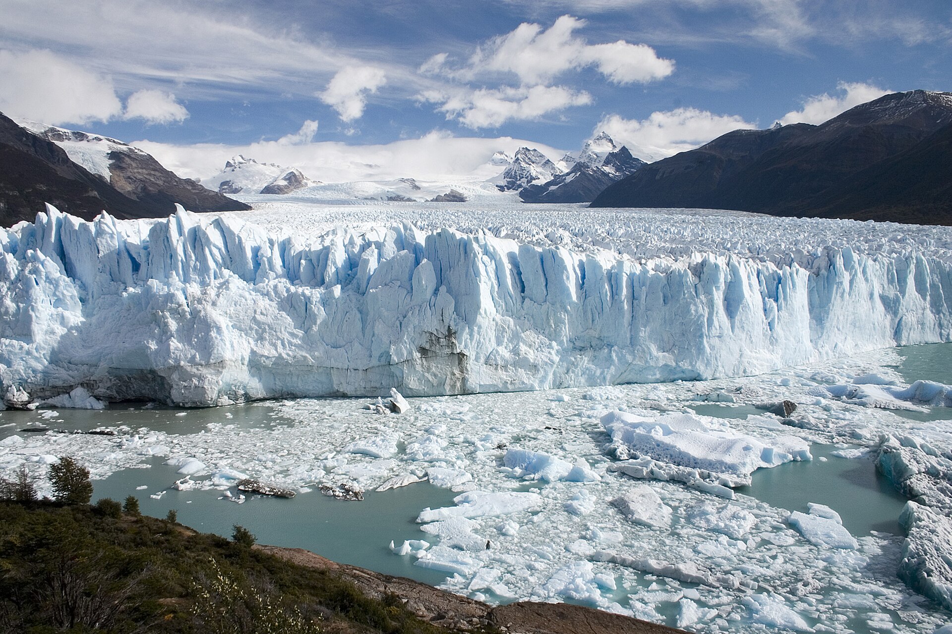
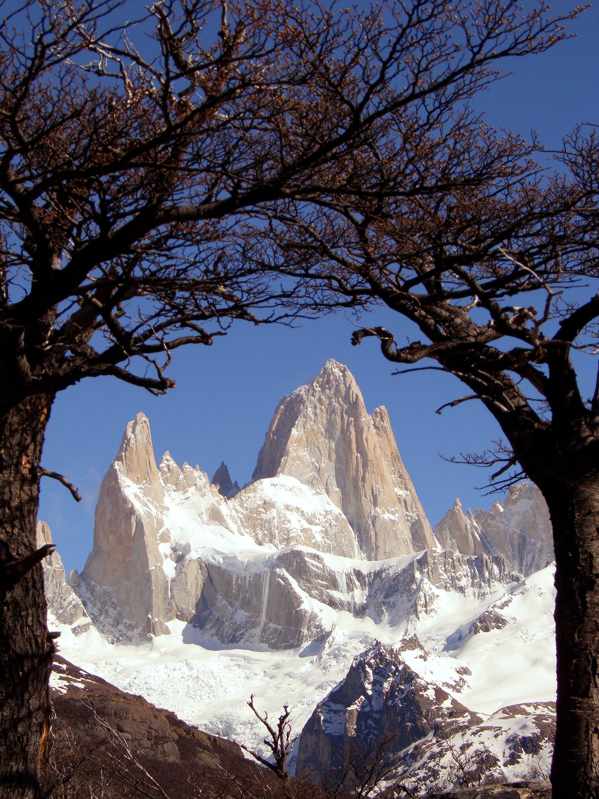
Laguna de los Tres is the most iconic trek in Argentine Patagonia and one of the most spectacular hikes in the world. Located at the foot of Mount Fitz Roy (3,405 m) in Los Glaciares National Park, Santa Cruz province (lat -49.2717, lng -72.9958), this turquoise glacial lagoon offers Patagonia's most famous view: the Fitz Roy massif reflected in its waters. The trek covers 25 km round trip from El Chalten, with a cumulative elevation gain of 750 metres and a duration of 8-10 hours. The trail is free and does not require a guide, although the final 400 metres of elevation are the most demanding section. The lagoon sits at 1,170 metres altitude and is fed by the Tres Glacier. It is the most reproduced image of Patagonia, and The North Face logo is inspired by the Fitz Roy silhouette.
Getting there — distances & times
| From | Distance | Flight | Bus | Drive |
|---|---|---|---|---|
| Buenos Aires → Bariloche | 1640 km | 2 h 20 | 22 h | 18 h |
| Buenos Aires → El Calafate | 2700 km | 3 h 15 | 40 h | 35 h |
| Buenos Aires → Ushuaia | 3050 km | 3 h 35 | 50+ h | — |
| Bariloche → El Calafate | 1490 km | 1 h 45 | 28 h | 24 h |
| El Calafate → Ushuaia | 600 km | 1 h 15 | 18 h | 14 h |
Month-by-month climate
| Month | Temp. | Rain | Crowds | Note |
|---|---|---|---|---|
| Jan | 8° / 22°C | 40 mm | High season | |
| Feb | 8° / 22°C | 40 mm | ||
| Mar | 6° / 18°C | 50 mm | ||
| Apr | 3° / 14°C | 70 mm | ||
| May | 0° / 10°C | 90 mm | ||
| Jun | -2° / 6°C | 110 mm | Ski season | |
| Jul | -2° / 6°C | 120 mm | ||
| Aug | -1° / 8°C | 90 mm | ||
| Sep | 1° / 12°C | 60 mm | ||
| Oct | 4° / 16°C | 40 mm | ||
| Nov | 6° / 19°C | 40 mm | ||
| Dec | 7° / 21°C | 40 mm |
How to Get to Laguna de los Tres
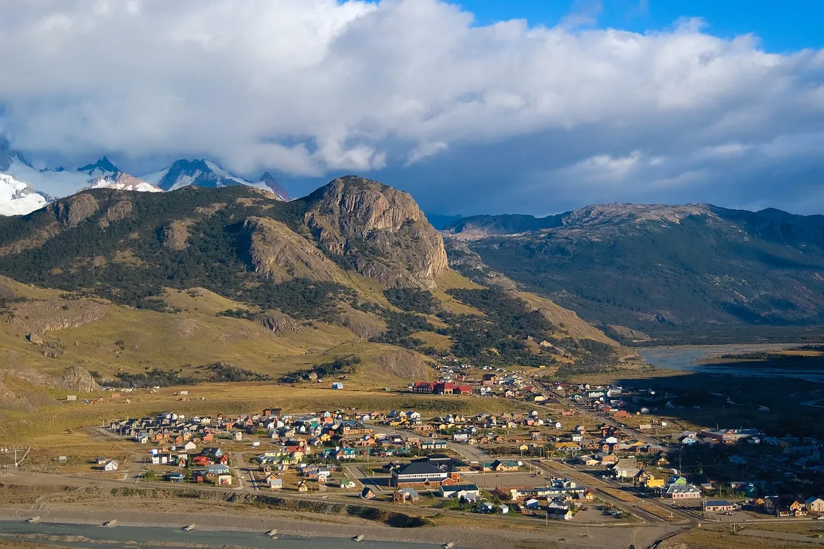
The trek starts from the town of El Chalten, Argentina's national trekking capital.
Trailhead
The trail begins at the Fitz Roy path, signposted at the northern end of El Chalten (San Martin street). There is a National Parks information centre where you register your departure. The total distance is 25 km round trip (12.5 km each way). Setting out between 6:00 and 7:00 AM is recommended for the best light at the lagoon and to avoid afternoon wind.
Trail Stages
The first 10 km are of moderate difficulty, passing through lenga and nire forests with occasional views of Fitz Roy. You pass Campamento Poincenot at km 10 (free campsite with water). The final 2.5 km are the most challenging: a steep 400-metre ascent over a rocky moraine trail (1.5 hours). The reward at the top is the lagoon with the Fitz Roy granite wall directly ahead.
Getting to El Chalten
El Chalten is 220 km from El Calafate (3 hours via RN 40). Daily buses (USD 15-25). The nearest airport is El Calafate (FTE), with daily flights from Buenos Aires. There is no airport in El Chalten.
What to See and Do on the Trek
The Lagoon and Fitz Roy
The climactic moment: upon cresting the glacial moraine, Laguna de los Tres appears suddenly with the Fitz Roy massif dominating the horizon. On calm days, the reflection of Fitz Roy in the turquoise waters creates Patagonia's most famous postcard image. The lagoon is fed by the Tres Glacier hanging from the granite spires. Sunrise here (for those camping at Poincenot) is a spectacle: the rock turns deep red with the first rays of sun, a phenomenon known as alpenglow.
Fitz Roy Viewpoint
One kilometre from the trailhead there is a viewpoint with the first panoramic view of Fitz Roy and the surrounding spires. This is where most people take their first photo. The contrast between the Patagonian forest and the granite towers is striking.
Campamento Poincenot
At 10 km from the start, this free campsite on the banks of the Rio Blanco is the base for those wanting to do the trek in two days or see sunrise at the lagoon. It has camping areas, river water and latrines. There are no food services: bring everything.
Laguna Sucia
A short detour from Laguna de los Tres leads to Laguna Sucia, fed by the Piedras Blancas Glacier. Despite its name, it is a spectacular mirror of water with a view of the east face of Fitz Roy. It adds 30-45 minutes to the trek.
Best Time to Visit
- Summer (December-February): The best season. Longest days (up to 17 hours of light), temperatures of 5-20 degrees, snow-free trails. January and February have the most stable weather. High season: trails are busy.
- Autumn (March-April): Excellent. Fewer people, lenga forests in golden and red colours, shorter but sufficient days. Early snowfall possible in April.
- Spring (October-November): El Chalten opens for the season. Upper trails may have snow and mud. Fewer tourists. October is unpredictable; November more stable.
- Winter (May-September): Trails closed or with deep snow. Only for experienced mountaineers with winter equipment. El Chalten has reduced services.
Practical Information
Difficulty and Preparation
High difficulty. 25 km and 750 m elevation gain require good physical fitness. The final 400 m of ascent are demanding (loose rocks, steep gradient). Bring: waterproof trekking boots, layered clothing (weather changes in minutes), waterproof windbreaker, trekking poles (highly recommended), 2 litres of water, energy food, sun protection and hat. Patagonian wind can exceed 80 km/h.
Cost
The trek is completely free. There is no entry fee to Los Glaciares National Park from El Chalten (unlike the Perito Moreno sector). Camping at Poincenot is free.
Accommodation in El Chalten
El Chalten has hostels from USD 15-25, cabins from USD 60-100 and boutique hotels from USD 150. Book in advance during high season (January-February). The dining scene has grown substantially: craft beer, Patagonian lamb restaurants and pizzerias.
Connectivity
El Chalten has Wi-Fi in hotels and restaurants, but mobile signal is limited (only in town). There is no signal on the trail. Download offline maps.