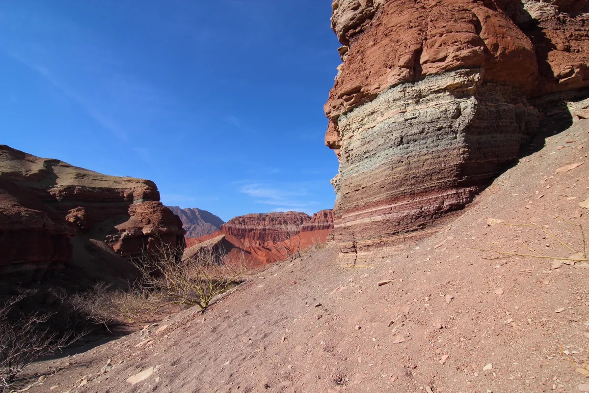
The Quebrada de las Conchas (also known as Quebrada de Cafayate) is a 100-km geological corridor along National Route 68 between Salta city and Cafayate, Argentina (lat -25.8667, lng -65.8833). Over millions of years, the Conchas River and wind erosion carved spectacular rock formations into red, ochre and white sandstone layers dating from the Cretaceous period (80-100 million years ago). The most photographed sites include the Garganta del Diablo (Devil's Throat — a narrow canyon with 50-meter vertical walls), the Amphitheater (a circular cavity with perfect natural acoustics), El Sapo, El Fraile, Los Castillos, El Obelisco and the House of Windows. The road is fully paved and can be driven in 2.5-3 hours without stops, but plan at least half a day to stop at the viewpoints and formations. It is part of the classic NOA circuit that includes Cachi and the Calchaqui Valleys.
Getting there — distances & times
| From | Distance | Flight | Bus | Drive |
|---|---|---|---|---|
| Buenos Aires (EZE) | 1500 km | 2 h 20 | 20–22 h | 15–17 h |
| New York (JFK) | 9400 km | 12 h + 2 h 20 layover | — | — |
| Madrid (MAD) | 11300 km | 14 h + 2 h 20 layover | — | — |
| São Paulo (GRU) | 2800 km | 4 h 30 | — | — |
| Córdoba | 890 km | 1 h 30 | 11–13 h | 9–10 h |
| Mendoza | 1200 km | 2 h | 17–19 h | 13–15 h |
Month-by-month climate
| Month | Temp. | Rain | Crowds | Note |
|---|---|---|---|---|
| Jan | 16° / 28°C | 180 mm | Rainy summer | |
| Feb | 15° / 27°C | 155 mm | ||
| Mar | 14° / 26°C | 110 mm | ||
| Apr | 11° / 24°C | 30 mm | Dry season starts | |
| May | 8° / 22°C | 8 mm | ||
| Jun | 5° / 20°C | 3 mm | ||
| Jul | 4° / 20°C | 3 mm | Winter break | |
| Aug | 6° / 22°C | 5 mm | ||
| Sep | 9° / 25°C | 10 mm | Clear skies | |
| Oct | 12° / 27°C | 25 mm | ||
| Nov | 14° / 28°C | 60 mm | ||
| Dec | 16° / 28°C | 140 mm | Holidays |
Typical prices by category
| Category | Budget | Mid-range | Luxury |
|---|---|---|---|
| Hotel/night | USD 15–25 | USD 50–90 | USD 150–350 |
| Food/day | USD 12–18 | USD 25–40 | USD 60–120 |
| Day tour | USD 40–55 | USD 60–90 | USD 120–200 |
| Car rental/day | USD 30–45 | USD 50–70 | USD 90–150 |
Approximate ranges in USD as of April 2026. May vary with Argentine peso exchange rate.
How to Get There
The Quebrada de las Conchas is traversed via RN 68, fully paved and in excellent condition.
From Salta
Head south on RN 68. The rock formations begin after Alemania (km 50 approx.) and intensify in the last 50 km before Cafayate. The total Salta-Cafayate journey is 189 km, about 3 hours without stops. The main formations are signposted with parking areas. We recommend leaving Salta early for the best light (morning sun illuminates the red walls).
From Cafayate
If staying in Cafayate, driving through the gorge toward Salta in the morning offers front-lit views of the formations. The first stops are just 15-20 km from Cafayate. A half-day round trip from Cafayate visiting the main points and returning is possible.
Transport
Daily buses run Salta-Cafayate (El Indio and Flecha Bus, 3.5 hours, USD 8-12) but do not stop at the formations. To enjoy the stops, rent a car, join an organized tour, or cycle (experienced cyclists cover the route in 1-2 days with camping).
What to See
Garganta del Diablo (Devil's Throat)
The most impressive formation: a narrow canyon with vertical red sandstone walls rising 50 meters. Accessed by a short trail (400 m) from the road. Midday light enters vertically and sets the walls ablaze in intense red. It is a claustrophobic yet spectacular experience. Free, always open.
The Amphitheater
A natural circular cavity carved into the rock with perfect acoustics. Local musicians sometimes play folklore inside, and the sound reverberates extraordinarily. Reached through a narrow passage between 20-meter walls. It is one of the most visited and photographed points. 200-meter walk from parking.
Rock Formations: El Sapo, El Fraile, Los Castillos
Along the route there are dozens of formations with descriptive names: El Sapo (rock resembling a giant toad), El Fraile (silhouette of a monk), Los Castillos (sandstone towers that look like medieval walls), El Obelisco (30-meter rock needle), the House of Windows (erosion that created natural windows). Each formation has a small parking area and sign. Visible from the road but worth getting out and walking.
Geology and Landscape
The gorge's layers reveal 500 million years of geological history. Colors range from intense red (iron oxide) to white (limestone) and green (copper). Marine fossils can be seen in some rocks, evidence that this area was once an ocean floor. The contrast between red rock and the intense blue NOA sky creates an extraordinary photographic setting.
When to Visit
- Fall (March-May): Golden light, perfect temperatures, clean skies. Best season for photography.
- Winter (June-August): Dry and sunny weather, short days but excellent light. Cold nights. Peak season in July.
- Spring (September-November): Rising temperatures, good light, few tourists. Excellent.
- Summer (December-February): Intense heat (35-40°C in the gorge). Possible rains that can cause river flooding. Avoid driving in rain. Strong midday light flattens colors; better early or at sunset.
Practical Information
Accommodation
There is no accommodation inside the gorge. Options are Salta (north) or Cafayate (south). Cafayate is the ideal choice: a charming town with wineries, good food and varied lodging. Hostels from USD 12, inns from USD 40, boutique hotels from USD 100.
On-Road Services
There are no gas stations or services between Salta and Cafayate in the 100 km of the gorge. Fill up before leaving. Bring plenty of water (minimum 2 liters per person), sunscreen, hat. No cell signal in much of the route.
Budget
Driving the Quebrada is free (no tolls or admission fees). Car rental in Salta: USD 30-50/day. Organized tour Salta-Cafayate with guide: USD 35-55. Bus Salta-Cafayate: USD 8-12. The main expense is transport.
Connectivity
Cell signal nonexistent or very weak in most of the gorge. Download offline maps before leaving. Good connectivity in Cafayate.